研究課題
International collaborative study on atmospheric turbulence based on simultaneous observations with the MU radar, small unmanned aerial vehicles (UAV), and radiosonde and tethered balloons
MUレーダー・小型無人航空機(UAV)・ラジオゾンデ気球・係留気球観測による大気乱流特性の国際共同研究
研究組織
| 代表者 | Hubert Luce (MIO, Toulon University, France) |
|---|---|
| 共同研究者 | Richard Wilson (LATMOS, CNRS, France) Hiroyuki Hashiguchi (RISH, Kyoto University) Masanori Yabuki (RISH, Kyoto University) L. Kantha (University of Colorado) D. Lawrence (University of Colorado) |
| 関連ミッション |
|
研究概要
The knowledge of atmospheric turbulence parameters is important, not only for understanding exchange processes in the lower atmosphere but also for applied aspects (propagation of electromagnetic and acoustic waves, aviation safety, and diffusion of atmospheric admixtures). For that objective, experimental in situ studies reported in the literature have been performed using balloon-borne radiosondes, tower-mounted instruments, tethered lifting systems, aircrafts, etc. Small unmanned aerial vehicles (UAV) have been employed for meteorological studies and atmosphere observations, due to the fast technological advances and the development of low-cost systems in recent years. These instruments have a promising future since they offer a wide range of possibilities and potential developments for more and more comprehensive and precise observations. The resulting information should provide a better understanding of various atmospheric processes and should contribute to help validate numerical models of atmosphere dynamics.
In particular, the controllable position of UAV, and thus the possibility of multiple measurements at the same location, their ease of operation and their possible re-use are major advantages over standard in situ instruments (that are mainly either limited in range or drifted by the wind). They can be equipped with any type of sensors, taking also benefit of recent technological improvements in sensor performances and radio communications. Recently, Lawrence and Balsley (2013) showed the potential of instrumented UAVs for measuring temperature structure constant and kinetic energy dissipation rate, which are key parameters for characterizing atmospheric turbulence.
The UAVs can be operated near ground-based remote-sensing instruments such as sodar or atmospheric radars for simultaneous and collocated measurements. Combined observations thus offer unprecedented opportunities for validating the measurements and for interpreting the observations made by all the instruments. The operational use of instrumented low-cost UAVs with recognized processing methods for measuring atmospheric parameters (wind, shear, temperature, stability, turbulence, …) can be of primary importance in humanosphere science for sensing in dangerous and remote areas (such as damaged nuclear power plants or near severe storms). The primary objective of the proposed research is thus to help interpret UAV observations in light of concurrent radar and balloon observations and numerical simulations, and reciprocally.
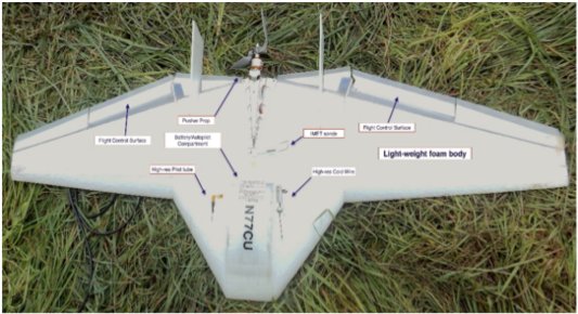
A collaboration between RISH and University of Colorado lead to three unprecedented field campaigns in June 2015, May-June 2016, and June 2017 called ShUREX involving instrumented UAVs, MU radar and radiosonde and tethered balloons. Simultaneous and nearly-collocated data were collected for retrieving a large variety of turbulence and structure parameters. The wealth of the datasets collected during various atmospheric conditions is such that a large variety of aspects on measurement physics and small-scale atmospheric dynamics can be studied. The MU radar measurements clearly reveal the coexistence at the same scales of turbulent irregularities and coherent structures, such as thin horizontally stratified and laminar gradients of temperature and humidity at the edges of more or less neutral layers, Kelvin-Helmholtz or convective vortices in turbulent regions, nearly-monochromatic gravity wave oscillations in association with turbulent events. UAV measurement physics is a subject area in its early stages: the UAV provides either time series at constant altitude (at a much higher frequency than a standard airplane, 1 Hz or much less at a speed of ~15 m/s) or time-series along vertical helical flights at a vertical ascent of ~2 m/s with typical diameter of ~100 m. Very little is known about the structure of the atmospheric fields at these small spatial and temporal scales. Consequently, it is not clear how the coherent structures detected by radar would affect the UAV measurements of turbulence parameters. The purpose of this study is to perform a cross-analysis of the observation results for estimating the potential biases in the measurements with the help of numerical simulations.

The University of Colorado DataHawk UAV
ページ先頭へもどる
2017年7月13日作成


