2021 Activity Report for Mission 5-3:
Space-Atmosphere-Ground Interaction in Daily Life
Updated: 2022/06/01
Research 1: Monitoring of the atmospheric environment with GNSS signals
Principal Investigator (PI): Masanori Yabuki, Hiroyuki Hashiguchi (RISH, Kyoto University)
Research collaborator(s): Toshitaka Tsuda(RISH, Kyoto University)
The radio waves transmitted from a global navigation satellite system (GNSS) such as global positioning system (GPS) are delayed and refracted by the Earth’s atmosphere. Measurement of the propagation phase delay of GNSS radio waves enables us to estimate atmospheric temperature and humidity, which are key parameters for understanding localized torrential rainfall and climate change. In FY2021, we have evaluated the GNSS-derived precipitable water vapor (PWV) by use of the GNSS data including the Quasi-Zenith Satellite System (QZSS) at Equatorial Atmosphere Radar (EAR) site. We constructed a database of the PWV observed by the dense-GNSS network and the water vapor Raman lidar in Shiga areas.
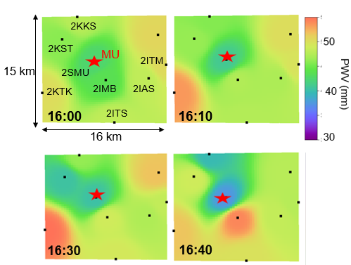
Figure: Horizontal distributions of GNSS-derived precipitable water vapor (PWV) before and after heavy rainfall around Shigaraki MU observatory at 16:0016:40 JST on July 2, 2018.
Publications, etc.
- Matsuki, U. Uchiho, E. Takeuchi, T. Hasegawa, M. Yabuki, Development of a water vapor Raman lidar with 266 nm laser, The 42nd Annual Meeting of The Laser Society of Japan (in Japanese), Jan. 12-14, 2022(Online).
Research 2: Ionospheric 3D tomography with GPS
Principal Investigator (PI): Mamoru Yamamoto (RISH, Kyoto University)
Research collaborator(s): Akinori Saito (Graduate School of Science, Kyoto University), Susumu Saito (Electrical Navigation Research Institute))
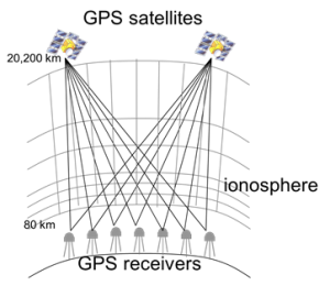
We are working on developing 3D tomography of ionospheric electron density using GPS observation network GEONET. The Electronic Navigation Research Institute (ENRI) conducts real-time analysis using real-time GPS data obtained from 200 points nationwide. The daily electron density distribution over Japan has a latitude/longitude resolution of 1-degree x 1-degree, and an altitude resolution of 20 km (maximum) is obtained every 15 minutes. Comparing ionospheric electron density observations with MU radar and tomography analysis shows that they agree relatively well, but the ionospheric altitude tends to be too high by tomography. This year, we developed a new analysis method that adds ionospheric parameters from regional operating ionosondes in addition to the conventional GPS-TEC data from GEONET1). The results were good, and we found that both the magnitude and the height of the electron density give probable results both in the ionosphere under normal conditions and during a magnetic storm2) 3). In addition, we developed a GPS-TEC receiver based on the low-cost (tens of thousands of yen) dual-frequency GNSS module that has recently begun to spread. The results are good, and we obtained good TEC data that can be used for ionospheric research4). Furthermore, we developed a dual-frequency beacon transmitter and antenna for the sounding rocket S-520-32, which launch will be in July-August 20225).
 |
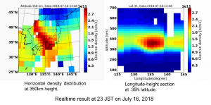 |
Figures: (left) Concept of the GPS-TEC tomography, (right) Example of the real-time 3D tomograph
Publications, etc.
- Ssessanga, N. et al., Complementing regional ground GNSS-STEC computerized ionospheric tomography (CIT) with ionosonde data assimilation, GPS solutions, GPSS-D-20-00186R4, May 2021.
- Ssessanga, N. et al., Assessing the performance of a Northeast Asia Japan-centered 3-D ionosphere specification technique during the 2015 St. Patrick’s Day geomagnetic storm, EPS, 73(1), doi:10.1186/s40623-021-01447-8, 2021.
- Ssessanga, N., M. Yamamoto, S. Saito, Assessing the performance of a Northeast Asia regional ionosphere specification technique during the 2015 St. Patrick’s Day solar storm, Japan Geophysical Union Meeting 2021, June 4, 2021.
- Kawakami, K., M. Yamamoto, S. Saito, N. Ssessanga, Development of low-cost and multi GNSS constellation TEC measurement system, 150th SGEPSS Fall Meeting, November 2, 2021. (in Japanese)
- Yamamoto, M., K. Kurokawa, Development of ionospheric total electron content measurement system from sounding rocket to ground, 150th SGEPSS Fall Meeting, November 2, 2021. (in Japanese)
Research 3: Development of simulation model of geomagnetically induced current flowing in Japanese power grid
Principal Investigator (PI): Yusuke Ebihara (RISH, Kyoto University)
Research collaborator(s): Yoshiharu Omura (RISH, Kyoto University), Tadanori Goto (Kyoto University), Satoko Nakamura (RISH, Kyoto University), Shinichi Watari (NICT), Takashi Kikuchi (Nagoya University), Takashi Tanaka (Kyushu University), Shigeru Fujita (ROIS)
Geomagnetically induced currents (GIC) flow in power grid when geomagnetic disturbances, such as magnetic storms, occur, potentially giving rise to irreversible damage on power grids. The amplitude of GIC is relatively low at low magnetic latitudes, such as Japan, but the potential risk could not be zero, according to historical records of super solar flares and super geomagnetic storms. Assuming that the super magnetic storm of 1859 occurs again, we calculated GIC flowing through transformers at 3 Japanese substations at which we have conducted the measurements of GIC. The maximum GIC is expected to be 89± 30 A in the 3 particular substations. For the electric facility at which GIC of 129 A flowed during the large magnetic storm of 2003, the maximum GIC is expected to be 496± 174 A, which exceeds the threshold (225 A) determined by the North American Electric Reliability Corporation (NERC). It does not immediately pose a danger, but we may need to pay attention to super magnetic storms, like what occurred in 1859.
Publication
- Ebihara, Y., S. Watari and S. Kumar, Prediction of geomagnetically induced currents (GICs) flowing in Japanese power grid for Carrington-class magnetic storms, Earth, Planets and Space, 73:163, doi:10.1186/s40623-021-01493-2, 2021.
Research 4: Simultaneous observations of atmospheric turbulence with MU (Middle and Upper atmosphere) radar, and small unmanned aerial vehicles (UAV)
Principal Investigator (PI): Hiroyuki Hashiguchi (RISH, Kyoto University)
Research collaborator(s): Lakshmi Kantha, Dale Lawrence (University of Colorado, USA), Hubert Luce (RISH, Kyoto University), and Richard Wilson (LATMOS, CNRS, France), and Masanori Yabuki (RISH, Kyoto University)
Turbulence mixing is an important process that contributes to the vertical transport of heat and substances, but it is difficult to observe because its scale is very small. In a research collaboration between Japan, the United States, and France, the ShUREX (Shigaraki, UAV-Radar Experiment) campaign has been carried out using simultaneously small UAVs developed by the University of Colorado and the MU radar. The campaign demonstrated the validity and utility of the radar range imaging technique in obtaining very high vertical resolution (~20 m) images of echo power in the atmospheric column. Figure shows the frequency spectrum of the temperature obtained when the UAV flew horizontally in strong turbulence. The spectrum obeyed the -5/3 power law, and the wind spectrum also followed the -5/3 power law.
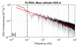
Frequency spectrum of the temperature obtained by UAV level flight. The red line indicates the slope of -5/3. [Luce et al., 2019]
Publications, etc.
- H. Hashiguchi, Phased Array Atmospheric Radar, Invited talk, International E-Conference on Advances in Information Technology and Research, Online, May 31-June 1, 2021.
- Hubert Luce, Abhiram Doddi, Dale Lawrence, Tyler Mixa, Masanori Yabuki, Koji Nishimura, and Hiroyuki Hashiguchi, Characterization of atmospheric turbulence at Syowa station from Datahawk UAVs, stratospheric balloons and the PANSY radar, Invited talk, The 12th Symposium on Polar Science, Online, November 15-18, 2021.
Research 5: Impact of high-energy particle precipitations from space on Earth’s upper atmosphere
Principal Investigator (PI):Satoshi Kurita (RISH, Kyoto University)
Research collaborator(s): Hirotsugu Kojima (RISH, Kyoto University), Yoshizumi Miyoshi (ISEE, Nagoya University), Shinji Saito (NICT)
Electromagnetic waves are naturally generated in the Earth’s magnetosphere. High-energy particles trapped in the magnetosphere are precipitated into the Earth’s upper atmosphere through interaction with these waves. The precipitations cause ionization and heating of the upper atmosphere, which results in enhanced chemical reactions in the upper atmosphere. This process might significantly contribute to a change in the composition of the upper atmosphere. To understand the process, we aim to evaluate the amount of high-energy particle precipitations from the satellite observation.
We statistically clarified the propagation characteristics of whistler-mode chorus waves based on the Japanese “Arase” satellite. We also performed a case study of anomalous ionospheric density enhancement at an altitude of ~60 km in association with auroras related to chorus waves. The data obtained by EISCAT radar and the auroral camera network deployed in the Scandinavian area is used together with the Arase measurement in the study. The anomalous ionospheric density enhancement can be explained by the precipitation of high energy electrons into the ionosphere, which results from pitch angle scattering of the electrons by chorus waves observed by the Arase satellite. A data-driven numerical experiment shows that the high energy electron precipitation causes a decrease in ozone by more than 10% in the mesosphere.
Publication
- Miyoshi, Y., Hosokawa, K., Kurita, S. et al. Penetration of MeV electrons into the mesosphere accompanying pulsating aurorae. Sci Rep 11, 13724 (2021). https://doi.org/10.1038/s41598-021-92611-3.