2019 Activity Report for Mission 5-3:
Space-Atmosphere-Ground Interaction in Daily Life
Updated: 2020/05/20
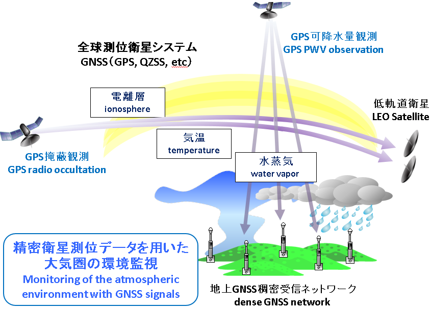
Research 1: Monitoring of the atmospheric environment with GNSS signals
Principal Investigator (PI): Masanori Yabuki (RISH, Kyoto University)
Research collaborator(s): Toshitaka Tsuda, Noersomadi (RISH, Kyoto University)
The radio waves transmitted from a global navigation satellite system (GNSS) such as global positioning system (GPS) are delayed and refracted by the Earth’s atmosphere. Measurement of the propagation phase delay of GNSS radio waves enables us to estimate atmospheric temperature and humidity, which are key parameters for understanding localized torrential rainfall and climate change. In FY2019, we have analyzed the GNSS-derived precipitable water vapor (PWV) by use of the dense-GNSS network in Kyoto and Shiga areas. The GNSS observation using the Quasi-Zenith Satellite System (QZSS) has started at Equatorial Atmosphere Radar (EAR) site.
Publications, etc.
- Yabuki, M. et al., Spatial and temporal distribution of tropospheric water vapor observed by a Raman lidar and a GNSS receiver network over Shigaraki, Japan, Japan Geoscience Union Meeting 2019, May 26-30, 2019.
- Yabuki, M., et al., A Raman lidar with a deep ultraviolet laser for continuous water vapor profiling in the atmospheric boundary layer, The 29th International Laser Radar Conference (ILRC29)(Hefei, China,) June 24-28, 2019.
Research 2: Ionospheric 3D tomography with GPS
Principal Investigator (PI): Mamoru Yamamoto (RISH, Kyoto University)
Research collaborator(s): Akinori Saito (Graduate School of Science, Kyoto University), Susumu Saito (Electrical Navigation Research Institute))
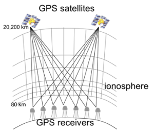
GPS is established as a standard of global positioning service. With the GPS system, Total Electron Consistent (TEC) in the ionosphere can be measured from the difference in the propagation of two radio waves with different frequencies. In Japan, GEONET, the network of electronic reference points is operated by the Geographical Survey Institute. The TEC data from GEONET (hereafter referred as GPS-TEC) has been widely used for the study of the ionosphere. We have been conducting three-dimensional (3D) tomographic analysis of the GPS-TEC to monitor the 3D distribution of ionospheric plasma density over Japan. The purpose of this study is to promote the GPS-TEC tomography jointly with the Graduate School of Science and the Electronic Navigation Research Institute.
By using every-second data from GEONET, we developed a software system for the real-time 3D tomography analysis every 15 minutes. The real-time ionospheric 3D tomography is conducted since March 1996 by ENRI. The results are available from http://www.enri.go.jp/cnspub/tomo3/Analysis. We also worked on mass analysis of past data of GEONET. Based on the supercomputer of Kyoto University, we realized to execute 3D tomographic analysis of every 15 minutes with data from 200 GEONET stations in about 30 hours. In this fiscal year, we are developing a tomographic analysis method that mixes heterogeneous data that incorporates other observation data such as ionosonde and have reached obtaining the initial results from that. Under collaboration with researchers from Korea and Taiwan, we now plan to expand the analysis area including Japan, Korea and Taiwan regions. Recently, there are many receivers that can handle signals from satellite positioning systems other than GPS. Such receivers (called GNSS receivers) have also become extremely cheaper than before. We would like to proceed utilization of such new GNSS receivers in our study.
 |
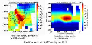 |
Figures: (left) Concept of the GPS-TEC tomography, (right) Example of the real-time 3D tomograph
Publications, etc.
- S. Saito, et al., Real-time 3-D Ionospheric Tomography and Its Validation by the MU Radar, APRASC 2019, New Delhi, March 2019S.
- S. Saito, M. Yamamoto, A. Saito, and C.-H. Chen, Real-time 3-D ionospheric tomography over Japan with GNSS observations, URSI JRSM, Tokyo, Sep. 2019.
- Ssessanga Nicholas, Utilizing 4D-var technique to image South African regional ionosphere, 4th PSTEP International Symposium (PSTEP-4), Nagoya University, Jan 28-30, 2020.
Research 3: Development of simulation model of geomagnetically induced current flowing in Japanese power grid
Principal Investigator (PI): Yusuke Ebihara (RISH, Kyoto University)
Research collaborator(s): Yoshiharu Omura (RISH, Kyoto University), Tadanori Goto (Kyoto University), Satoko Nakamura (RISH, Kyoto University), Shinichi Watari (NICT), Takashi Kikuchi (Nagoya University), Takashi Tanaka (Kyushu University), Shigeru Fujita (Meteorological College)
When a coronal mass ejection (CME) hits the Earth, a magnetic storm can occur. Large-scale electric current starts flowing in the magnetosphere and the ionosphere, which induces electric current in power grid. This is called a geomagnetically induced current (GIC). The amplitude of GIC was observed to exceed 100 A in Japan. This observational fact suggests that the Japanese power grid is probably not safe. To develop the GIC flowing in the Japanese power grid, we solved the geomagnetically induced electric field (GIE) by the finite-difference time-domain (FDTD) method. In addition to the geographical characteristics, the uneven distribution of substation/power plant is found to make the GIC in Japan complicated. We also modeled a power grid model for voltage equal to, or larger than 187 kV in Japan. Using a global MHD simulation, we also investigated the auroral substorm during the auroral substorm, as well as the ring current in terms of energy flow. The former process is important for GIC flowing at high-latitudes, whereas the latter one is for GIC flowing at mid- and low-latitudes.
Publication
- Ebihara, Y., Mechanism of auroral breakup, Japanese Journal of Multiphase Flow, 33, 3, 267-274, doi:10.3811/jjmf.2019.T012, 2019.
- Ebihara, Y., and T. Tanaka, Evolution of auroral substorm as viewed from MHD simulations: Dynamics, energy transfer and energy conversion, Reviews of Modern Plasma Physics, 4:2, doi:10.1007/s41614-019-0037-x, 2020.
- Ebihara, Y., L. C. Lee, and T. Tanaka, Energy flow in the Region 2 field-aligned current region under queai-steady condition, J. Geophys. Res. Space Res., 125, 2, e2019JA026998, doi:10.1029/2019JA026998, 2020.
Research 4: Simultaneous observations of atmospheric turbulence with MU (Middle and Upper atmosphere) radar, and small unmanned aerial vehicles (UAV)
Principal Investigator (PI): Hiroyuki Hashiguchi (RISH, Kyoto University)
Research collaborator(s): Mamoru Yamamoto, Masanori Yabuki (RISH, Kyoto University), Lakshmi Kantha, Dale Lawrence (University of Colorado, USA), Hubert Luce (Toulon-Var Univ., France), and Richard Wilson (LATMOS, CNRS, France)
Turbulence mixing is an important process that contributes to the vertical transport of heat and substances, but it is difficult to observe because its scale is very small. In a research collaboration between Japan, the United States, and France, the ShUREX (Shigaraki, UAV-Radar Experiment) campaign has been carried out using simultaneously small UAVs developed by the University of Colorado and the MU radar. The campaign demonstrated the validity and utility of the radar range imaging technique in obtaining very high vertical resolution (~20 m) images of echo power in the atmospheric column. Figure shows the frequency spectrum of the temperature obtained when the UAV flew horizontally in strong turbulence. The spectrum obeyed the -5/3 power law, and the wind spectrum also followed the -5/3 power law.
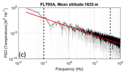
Frequency spectrum of the temperature obtained by UAV level flight. The red line indicates the slope of -5/3. [Luce et al., 2019]
Publications, etc.
- L. Kantha, H. Luce, and H. Hashiguchi, Mid-level Cloud-base Turbulence: Radar Observations and Models, J. Geophys. Res.: Atmosphere, 124, doi:10.1029/2018JD029479, 2019.
- L. Kantha, H. Luce, H. Hashiguchi, and A. Doddi, Atmospheric structures in the troposphere as revealed by high-resolution backscatter images from MU radar operating in range-imaging mode, Progress in Earth and Planetary Science, 6:32, doi:10.1186/s40645-019-0274-1, 2019.
- H. Luce, L. Kantha, H. Hashiguchi, and D. Lawrence, Estimation of Turbulence Parameters in the Lower Troposphere from ShUREX (2016-2017) UAV Data, Atmosphere, 10, 384, doi:10.3390/atmos10070384, 2019.
Research 5: Monitoring of the atmospheric environment from space
Principal Investigator (PI):Masato Shiotani (RISH, Kyoto University)
Research collaborator(s): Akinori Saito (Graduate School of Science, Kyoto University)
Global satellite observation of the earth’s atmosphere from space is one of the most important information sources for understanding the change in atmospheric environment. On the basis of social and scientific requirements we propose a next-generation satellite mission to observe temperature and wind fields, and distributions of atmospheric trace gases from the middle atmosphere (stratosphere and mesosphere) to the upper atmosphere (thermosphere and ionosphere) where we can see clear signs from the lower atmosphere as a result of human activities. In 2009- 2010 the Superconducting Submillimeter-Wave Limb-Emission Sounder (SMILES) on the International Space Station demonstrated a 4 K mechanical cooler for high-sensitivity submillimeter limb-emission sounding of atmospheric observations. Based on the SMILES heritage, we investigate new observation concepts for the atmospheric environmental observations for the next era.
Publication
- Shiotani, M., et al. (2019). A Proposal for Satellite Observation of the Whole Atmosphere – Superconducting Submillimeter-Wave Limb-Emission Sounder (Smiles-2). Presented at the IGARSS 2019 – 2019 IEEE International Geoscience and Remote Sensing Symposium. https://doi.org/10.1109/igarss.2019.8898423
- Baron, P., et al. (2020). Potential for the measurement of mesosphere and lower thermosphere (MLT) wind, temperature, density and geomagnetic field with Superconducting Submillimeter-Wave Limb-Emission Sounder 2 (SMILES-2). Atmospheric Measurement Techniques, 13(1), 219–237. https://doi.org/10.5194/amt-13-219-2020