2018 Activity Report for Mission 5-3: Space-Atmosphere-Ground Interaction in Daily Life
Updated: 2019/04/25
Research 1: Space Debris Observation, and Orbital Modeling
Principal Investigator (PI): Hirotsugu Kojima (RISH, Kyoto University)
Research collaborator(s): Mamoru Yamamoto, Hiroyuki (RISH, Kyoto University), Takuya Torii, and Takuhito Hirata (Graduate school of engineering, Kyoto University)
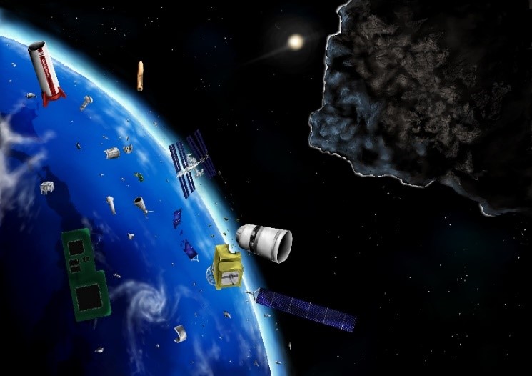
Space debris are remnants of satellites and rocket bodies and have hazardous effects on the maintenance and utilization of space infrastructures for daily life with positioning, observation, and communication functions, as well as endangering the international space station. We are investigating possible engineering approaches for tackling space debris issues from observation, and modeling points of view. In particular, we use the MU radar of Kyoto university for detecting space debris. The MU radar is designed for observing dynamic motions of the atmosphere. By establishing the observation methods of space debris by using an atmospheric radar, radar systems that are not ones for exclusive use of observing space debris are added to the ground network of radars for space debris. The RCS method and SRDI method were used for estimating 3D shape of space debris. Combining the observation from multiple directions by multiple radar beams, we succeeded in showing the estimation of the sizes of the space debris can be very close to the real sizes. On the other hand, we also calculated orbit elements of targeted space debris using the MU radar. We showed that the orbit elements for orbital plane can be determined with the error of 1 degree. Furthermore, the Range Weighting Function was adopted in the calculation to improve the determination accuracy of range distances.
Publications, etc.
- Takuya Torii, Hiroshi Yamakawa, Hiroyuki Hashiguchi, Mamoru Yamamoto , Orbit Determination of Unidentified Space Debris by Using MU Rader, 3rd ARN Symposium,Taichung, 2018.
- Takuto Ueno, Hiroshi Yamakawa, Hiroyuki Hashiguchi, Mamoru Yamamoto, ,Study on 3D Simulation for Shape Estimation of Space Debris Using MU Radar, 3rd ARN Symposium,Taichung, 2018.
- 鳥居拓哉, 山川宏, 橋口浩之, 山本衛 , Muレーダーを用いた観測による未知スペースデブリの軌道推定手法に関する研究, 第62回宇宙科学連合講演会, 久留米, 2018.
- 上埜拓仁, 山川宏, 橋口浩之, 山本衛 , MUレーダーを用いたスペースデブリの3次元形状推定に関する研究, 第62回宇宙科学連合講演会, 久留米, 2018.
Research 2: Monitoring of the atmospheric environment with GNSS signals
Principal Investigator (PI): Masanori Yabuki (RISH, Kyoto University)
Research collaborator(s): Toshitaka Tsuda, Noersomadi (RISH, Kyoto University)
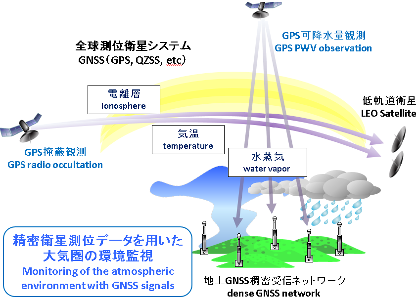
The radio waves transmitted from a global navigation satellite system (GNSS) such as global positioning system (GPS) are delayed and refracted by the Earth’s atmosphere. Measurement of the propagation phase delay of GNSS radio waves enables us to estimate atmospheric temperature and humidity, which are key parameters for understanding localized torrential rainfall and climate change. In FY2018, characteristics of atmospheric tropopause fluctuations were investigated by use of the temperature profiles derived from the satellite-based GPS Radio Occultation (RO) technique. In the method of ground-based GNSS meteorology, we have analyzed the GNSS-derived precipitable water vapor (PWV) by use of the dense-GNSS network in Kyoto and Shiga areas.
Publications, etc.
- Noersomadi, T. Tsuda, and M. Fujiwara, Characteristics of the tropical tropopause inversion layer using high-resolution temperature profiles retrieved from COSMIC GNSS Radio Occultation, Atmos. Chem. Phys. Discuss., https://doi.org/10.5194/acp-2018-1182, in review, 2018.
- Oigawa M., T. Tsuda, H. Seko, Y. Shoji, E. Realini, Data assimilation experiment of precipitable water vapor observed by a hyper-dense GNSS receiver network using a nested NHM-LETKF system, Earth Planets Space, 70:74. https://doi.org/10.1186/ s40623-018-0851-3, 2018.
Research 3: Ionospheric 3D tomography with GPS
Principal Investigator (PI): Mamoru Yamamoto (RISH, Kyoto University)
Research collaborator(s): Akinori Saito (Graduate School of Science, Kyoto University), Susumu Saito (Electrical Navigation Research Institute))
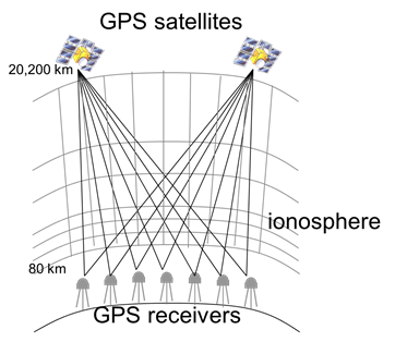
GPS is established as a standard of global positioning service. With the GPS system, Total Electron Consistent (TEC) in the ionosphere can be measured from the difference in the propagation of two radio waves with different frequencies. In Japan, GEONET, the network of electronic reference points is operated by the Geographical Survey Institute. The TEC data from GEONET (hereafter referred as GPS-TEC) has been widely used for the study of the ionosphere. We have been conducting three-dimensional (3D) tomographic analysis of the GPS-TEC to monitor the 3D distribution of ionospheric plasma density over Japan. The purpose of this study is to promote the GPS-TEC tomography jointly with the Graduate School of Science and the Electronic Navigation Research Institute.
By using every-second data from GEONET, we developed a software system for the real-time 3D tomography analysis every 15 minutes. The results are open to public from the web page. We started the real-time service in March 1996, and continue until now. Real-time ionospheric 3D tomography by ENRI: http://www.enri.go.jp/cnspub/tomo3/Analysis of past data
We worked on mass analysis of past data of GEONET. Based on the A-KDK collaborative research program, we used the super computer of Kyoto University, and realized to execute 3D tomographic analysis of every 15 minutes with data from 200 GEONET stations in about 30 hours. We have already finished the analysis from 2002 until now. We also try to analyze the data before 2002 back to 1996, the beginning of GEONET.
Comparison of the tomography results with existing ionosonde database and also with the MU radar IS experiment results were conducted. We now plan expansion of the analysis area including Japan, Korea and Taiwan regions.
 |
 |
Figures: (left) Concept of the GPS-TEC tomography, (right) Example of the real-time 3D tomography
Publications, etc.
- Yamamoto, R. Mizuno, S. Saito, A. Saito, GPS-TEC ionospheric 3D tomography; Massive data analysis with supercomputer, Japan Geoscience Union Japan Geoscience Union Meeting 2018, Makuhari, 2018年5月.
- Yamamoto, R. Mizuno, S. Saito, and A. Saito, Ionospheric three-dimensional GPS-TEC tomography over Japan and its statistical validation with ionosonde and COSMIC occultation measurements, 42nd COSPAR Scientic Assembly, Pasadena, USA, 14-22 July 2018.
- 斎藤 享, GEONETリアルタイムテ゛ータを用いた電離圏モニタリンク゛, 中間圏・熱圏・電離圏研究集会, 東京, 2018年9月.
- Saito, M. Yamamoto, A. Saito, and C. H. Chen, 電離圏3次元リアルタイムトモク゛ラフィーのMUレータ゛ーによる検証、MUレーダー・赤道大気レーダーシンポジウム, 京都, 2018年9月.
- Saito, M. Yamamoto, A. Saito, and C. H. Chen, GNSS-based real-time ionospheric 3-D tomography over Japan and its application to GNSS augmentation, International Association of Institutes of Navigation 2018, Chiba, November 2018.
- Saito, M. Yamamoto, and A. Saito, Real-time ionosphere 3-D tomography and its validation by MU radar incoherent scatter measurements, 地球電磁気・地球惑星圏学会, 名古屋大学, 2018年11月.
Research 4: Development of simulation model of geomagnetically induced current flowing in Japanese power grid
Principal Investigator (PI): Yusuke Ebihara (RISH, Kyoto University)
Research collaborator(s): Yoshiharu Omura (RISH, Kyoto University), Tadanori Goto (Kyoto University), Satoko Nakamura (RISH, Kyoto University), Shinichi Watari (NICT), Takashi Kikuchi (Nagoya University), Takashi Tanaka (Kyushu University), Shigeru Fujita (Meteorological College)
When a coronal mass ejection (CME) hits the Earth, a magnetic storm can occur. Large-scale electric current starts flowing in the magnetosphere and the ionosphere, which induces electric current in power grid. This is called a geomagnetically induced current (GIC). The amplitude of GIC was observed to exceed 100 A in Japan. This observational fact suggests that the Japanese power grid is probably not safe. To develop the GIC flowing in the Japanese power grid, we solved the geomagnetically induced electric field (GIE) by the finite-difference time-domain (FDTD) method. In addition to the geographical characteristics, the uneven distribution of substation/power plant is found to make the GIC in Japan complicated. We also modeled a power grid model for voltage equal to, or larger than 187 kV in Japan.
Publication
- Nakamura, S., Y. Ebihara, S. Fujita, T. Goto, N. Yamada, S. Watari and Y. Omura, Time domain simulation of geomagnetically induced current (GIC) flowing in 500 kV power grid in Japan including a three-dimensional ground inhomogeneity, Space Weather, 16, 1946-1959, doi:10.1029/2018SW002004, 2018.
Research 5: Simultaneous observations of atmospheric turbulence with MU (Middle and Upper atmosphere) radar, and small unmanned aerial vehicles (UAV)
Principal Investigator (PI): Hiroyuki Hashiguchi (RISH, Kyoto University)
Research collaborator(s): Mamoru Yamamoto, Masanori Yabuki (RISH, Kyoto University), Lakshmi Kantha, Dale Lawrence (University of Colorado, USA), Hubert Luce (Toulon-Var Univ., France), and Richard Wilson (LATMOS, CNRS, France)
Turbulence mixing is an important process that contributes to the vertical transport of heat and substances, but it is difficult to observe because its scale is very small. In a research collaboration between Japan, the United States, and France, the ShUREX (Shigaraki, UAV-Radar Experiment) campaign has been carried out using simultaneously small UAVs developed by the University of Colorado and the MU radar. The campaign demonstrated the validity and utility of the radar range imaging technique in obtaining very high vertical resolution (~20 m) images of echo power in the atmospheric column.

UAV developed by the University of Colorado
Publications, etc.
- Luce, H. Hashiguchi, L. Kantha, D. Lawrence, T. Tsuda, T. Mixa, and M. Yabuki, On the performance of the range imaging technique estimated using Unmanned Aerial Vehicles during the ShUREX 2015 campaign, IEEE Transact. Geosci. Remote Sens., 56 doi:10.1109/TGRS.2017.2772351, 2018.
- Luce, L. Kantha, H. Hashiguchi, D. Lawrence, T. Mixa, M. Yabuki, and T. Tsuda, Vertical structure of the lower troposphere derived from MU radar, Unmanned Aerial Vehicle and balloon measurements during ShUREX2015, Progress in Earth and Planetary Science, 5, doi:10.1186/s40645-018-0187-4, 2018.
- Kantha, H. Luce, and H. Hashiguchi, On a Numerical Model for Extracting TKE Dissipation Rate from Very High Frequency (VHF) Radar Spectral Width, Earth and Planetary Science, 70:205, doi:10.1186/s40623-018-0957-7, 2018.
- Luce, L. Kantha, H. Hashiguchi, D. Lawrence, and A. Doddi, Turbulence Kinetic Energy Dissipation Rates Estimated from Concurrent UAV and MU Radar Measurements, Earth and Planetary Science, 70:207, doi:10.1186/s40623-018-0979-1, 2018.
Research 6: Monitoring of the atmospheric environment from space
Principal Investigator (PI):Masato Shiotani (RISH, Kyoto University)
Research collaborator(s): Akinori Saito (Graduate School of Science, Kyoto University)
Global satellite observation of the earth’s atmosphere from space is one of the most important information sources for understanding the change in atmospheric environment. On the basis of social and scientific requirements we propose a next-generation satellite mission to observe temperature and wind fields, and distributions of atmospheric trace gases from the middle atmosphere (stratosphere and mesosphere) to the upper atmosphere (thermosphere and ionosphere) where we can see clear signs from the lower atmosphere as a result of human activities. In 2009- 2010 the Superconducting Submillimeter-Wave Limb-Emission Sounder (SMILES) on the International Space Station demonstrated a 4 K mechanical cooler for high-sensitivity submillimeter limb-emission sounding of atmospheric observations. Based on the SMILES heritage, we investigate new observation concepts for the atmospheric environmental observations for the next era.
Publication
- Shiotani, M., Satellite observation of the whole atmosphere – Superconducting Submillimeter-Wave Limb-Emission Sounder (SMILES-2) SPARC General Assembly 2018, Kyoto, Japan, October, 2018.