2017 Activity Report for Mission 5-3: Space-Atmosphere-Ground Interaction in Daily Life
Updated: 2018/06/20
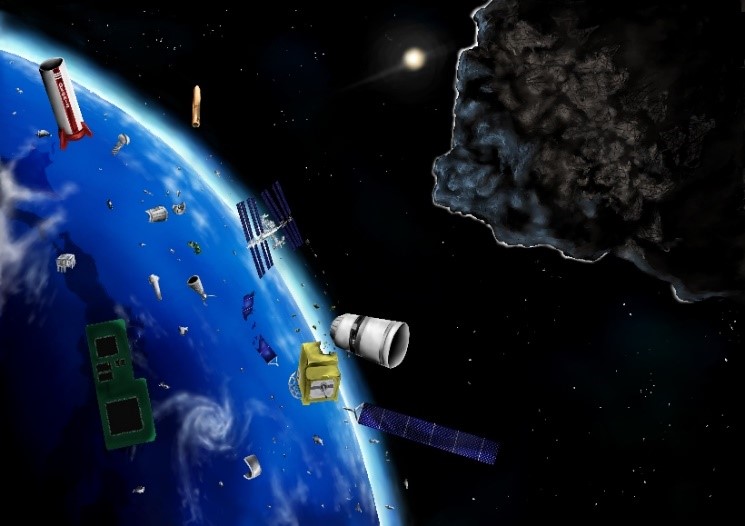
Research 1: Space Debris Observation, and Orbital Modeling (H. Yamakawa, K. Hoshi, N. Ikeda, Y. Kobayashi, K. Akari, T. Torii, T. Hirata, A. Shinjo, H. Tai, J. Miki (RISH, Kyoto University))
Space debris are remnants of satellites and rocket bodies and have hazardous effects on the maintenance and utilization of space infrastructures for daily life with positioning, observation, and communication functions, as well as endangering the international space station. We are investigating possible engineering approaches for tackling space debris issues from observation, modeling, and removal points of view.
Research Activities
- Orbit determination and characterization of space debris are important tasks in evaluating its trajectory evolution and collision probability with resident objects in space. Profiles of received signals by the MU radar were investigated, and the orbit, size, and spin a of some space debris were successfully estimated. Furthermore, orbit determination using data obtained from an optical sensor and a LIDAR system onboard a satellite in orbit was shown to be feasible.
- Numerical simulation program for understanding the echo profile of space debris using the MU radar system is being studied based on the FDTD method. A study of possibility of observing space debris in the vicinity of geostationary orbit using the MU radar system has started.
- The effect of electric and magnetic fields around the Earth on long-term small-scale space debris trajectory evolution and the effect of fragmentation on space debris orbital distribution have been investigated based on numerical simulation.
Publications
- N. Ikeda, T. Iwahori, T. Nishimura, M. Yamamoto, H. Hashiguchi, and H. Yamakawa, “Shape and Orbit Estimation Technique for Space Debris Observation Using MU Radar,” AMOS (Advanced Maui Optical and Space Surveillance Technologies Conference) 2017, September 19-22, 2017, Wailea Marriott, Maui, Hawaii, US.
- K. Hoshi, R. Serra, M. Vasile, and H. Yamakawa, “Study of the Effects of the Lorentz Force in Low Earth Orbit on Objects with High Area-to-mass Ratio,“ 31st International Symposium on Space Technology and Science, June 3-9, 2017, Matsuyama, Japan, ISTS Paper 2017-r-52.
- K. Akari, H. Yamakawa, T. Hanada, and K. Fujita, “Development of an Orbital Model for Small-Sized Space Debris Considering Electromagnetic Fields around the Earth, “ 31st International Symposium on Space Technology and Science, June 3-9, 2017, Matsuyama, Japan, ISTS Paper 2017-r-33.
- 鳥居拓哉, 西村泰河, 山川宏,“MUレーダを用いた未知スペースデブリの軌道推定手法に関する研究”,第61回宇宙科学連合講演会,新潟市,新潟県,朱鷺メッセ,2017年10月25-27日
- 池田成臣, 山本衛, 橋口浩之, 山川宏,“信楽MUレーダーを用いたスペースデブリ三次元形状推定手法に関する研究”,第61回宇宙科学連合講演会,新潟市,新潟県,朱鷺メッセ,2017年10月25-27日
- 平田拓仁, 山川宏,“MUレーダーによる3 次元SRDIシミュレーション形状推定”,第61回宇宙科学連合講演会,新潟市,新潟県,朱鷺メッセ,2017年10月25-27日
- 明里慶祐, 山川宏,“電磁場による微小サイズスペースデブリの軌道変化”,第61回宇宙科学連合講演会,新潟市,新潟県,朱鷺メッセ,2017年10月25-27日
Research 2: Monitoring of the atmospheric environment with GNSS signals (Masanori Yabuki, Toshitaka Tsuda (RISH, Kyoto University))
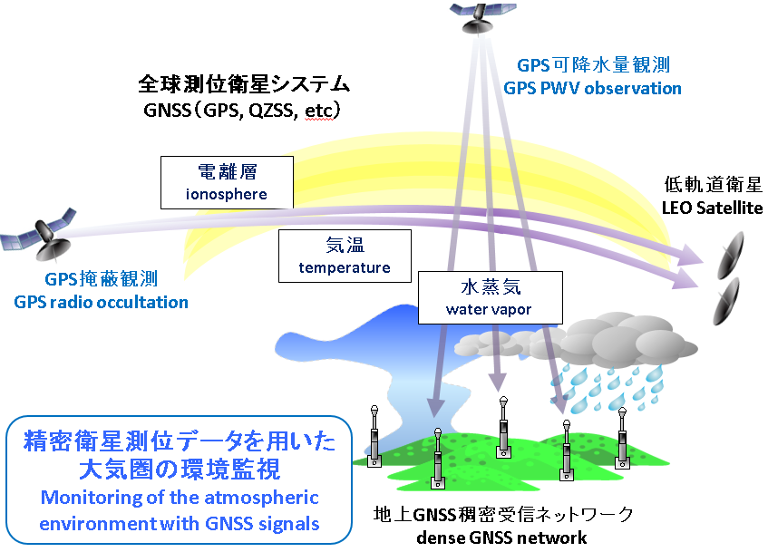
The radio waves transmitted from a global navigation satellite system (GNSS) such as global positioning system (GPS) are delayed and refracted by the Earth’s atmosphere. Measurement of the propagation phase delay of GNSS radio waves enables us to estimate atmospheric temperature and humidity, which are key parameters for understanding localized torrential rainfall and climate change.
(1) GPS radio occultation
Atmospheric tropopause fluctuations play an important role in the exchange mechanism between the troposphere and the stratosphere. We conducted a statistical comparison of the dry atmospheric temperature variations in the tropical upper troposphere and lower stratosphere (UTLS) region among datasets calculated from three retrieval methods of COSMIC GPS radio occultation (RO).
(2) Ground-based GNSS meteorology
Mechanisms of diurnal variation in water vapor and tropical deep convection over a complex terrain in the Bandung basin, Indonesia, were investigated by analyzing detailed observations including GNSS-derived precipitable water vapor (PWV), and high-resolution numerical model data.
A new calibration technique for water-vapor Raman lidar was proposed using GNSS-PWV and grid point values from the meso-scale model. We demonstrated this method’s potential by using the Raman lidar and GNSS observation data of the dense observation network around the Shigaraki MU radar observatory.
Publications, etc.
- Noersomadi and T. Tsuda; Earth, Planets and Space, 69, 125, doi:10.1186/s40623-017-0710-7, 2017.
- Oigawa,M., T. Matsuda, T. Tsuda, and Noersomadi; J. Meteorol. Soc. Japan, 95, 4, 261-281, 2017, DOI:10.2151/ jmsj.2017-015.
- Kakihara,H., M. Yabuki, F. Kitafuji, T. Tsuda, M. Tsukamoto, T. Hasegawa, H. Hashiguchi, and M. Yamamoto; AGU Fall Meeting 2017 (New Orleans, USA), A21A-2138, December 11-15, 2017.
Research 3: Ionospheric 3D tomography with GPS (Mamoru Yamamoto (RISH, Kyoto University), Akinori Saito (Graduate School of Science, Kyoto University), Susumu Saito (Electrical Navigation Research Institute))
GPS is established as a standard of global positioning service. With the GPS system, Total Electron Consistent (TEC) in the ionosphere can be measured from the difference in the propagation of two radio waves with different frequencies. In Japan, GEONET, the network of electronic reference points is operated by the Geographical Survey Institute. The TEC data from GEONET (hereafter referred as GPS-TEC) has been widely used for the study of the ionosphere. We have been conducting three-dimensional (3D) tomographic analysis of the GPS-TEC to monitor the 3D distribution of ionospheric plasma density over Japan. The purpose of this study is to promote the GPS-TEC tomography jointly with the Graduate School of Science and the Electronic Navigation Research Institute.
Research Activities
- Promotion of web publication on tomography results.
By using every-second data from GEONET, we developed a software system for the real-time 3D tomography analysis every 15 minutes. The results are open to public from the web page. We started the real-time service in March 1996, and continue the service in this fiscal year.
Real-time ionospheric 3D tomography by ENRI: http://www.enri.go.jp/cnspub/tomo3/ - Analysis of past data
We worked on mass analysis of past data of GEONET. Based on the A-KDK collaborative research program, we used the super computer of Kyoto University, and realized to execute 3D tomographic analysis of every 15 minutes with data from 200 GEONET stations in about 30 hours. We have already finished the analysis from 2002 until now. We also try to analyze the data before 2002 back to 1996, the beginning of GEONET. - Expansion of the analysis area
A GPS observation network has been developed in nearby countries such as Korea and Taiwan. We did sample analysis by adding data from both countries, and found that the quality of the results is improved.
Publications, etc.
- (peer-reviewed paper) S. Saito, S. Suzuki, M. Yamamoto, A. Saito, and C.-H. Chen, Real-Time Ionosphere Monitoring by Three- Dimensional Tomography over Japan, NAVIGATION: Journal of The Institute of Navigation, 64, 495-504, 2017.
- (peer-reviewed lecture on international symposium) Saito, M. Yamamoto, A. Saito, and C.-H. Chen, Ionosphere Monitoring and GNSS Correction by a Real-time Ionospheric Tomography System in Japan, Proc. Institute of Navigation GNSS+ 2017, 3434-3440, 2017.
- (lecture in international symposium) Susumu Saito, Mamoru Yamamoto, and Akinori Saito, Realtime three-dimensional ionospheric tomography and validation by MU radar, 15th MST Radar Workshop, May26-31, 2017, National Institute of Polar Research, Tachikawa, Japan.
- (lecture in international symposium) Mamoru Yamamoto, Ryo Mizuno, Susumu Saito, Akinori Saito, Study of ionosphere over Japan by using three-dimensional tomography, URSI GA 2017, August 19-26, 2017, Montreal, Canada.
Research 4: Development of simulation model of geomagnetically induced current flowing in Japanese power gridYusuke (Ebihara, Yoshiharu Omura, Satoko Nakamura (RISH, Kyoto University), Tadanori Goto (Graduate School of Engineering, Kyoto University), Shinichi Watari (NICT), Takashi Kikuchi (Nagoya University), Takashi Tanaka (Kyushu University), and Shigeru Fujita (Meteorological College))
When a coronal mass ejection (CME) hits the Earth, a magnetic storm can occur. Large-scale electric current starts flowing in the magnetosphere and the ionosphere, which induces electric current in power grid. This is called a geomagnetically induced current (GIC). The amplitude of GIC was observed to exceed 100 A in Japan. This observational fact suggests that the Japanese power grid is probably not safe. To develop the GIC flowing in the Japanese power grid, we solved the geomagnetically induced electric field (GIE) by the finite-difference time-domain (FDTD) method. Assuming the 3-dimensional distribution of the ground conductivity, we obtained the following results. (1) GIE is intensified near the coast line, which is known as a coastal effect. The GIC is further intensified where the curvature of the coastal line is small. (2) GIE is also intensified in the inland area due to the different thickness of the sediment layer. (3) The coastal effect depends on the depth of the sea. Using the calculated GIE, we solved the GIC flowing in the 500 kV power line in Japan. The following results are obtained. (1) When the source current in the ionosphere is directed westward, GIC tends to enter the grid on the westside of the land, and go out on the eastside. GIC is relatively low in the inland of Kanto and Chutoku where the azimuthal component of the conductivity gradient is small. (2) When the source current is directed northward, GIC tends to enter the grid on the northside, and go out on the southside. GIC appears to be intensified at a particular substation/power plant. The number of the substations/power plants is large in the urban area (Tokyo), whereas it is small in the provincial area. The uneven distribution of the substation/power plant is thought to result in the concentration of the GIC, that is, intensification of it. In addition to the geographical characteristics, the uneven distribution of substation/power plant is found to make the GIC in Japan complicated.
Presentation
S. Nakamura, Y. Ebihara, S. Fujita, T. Goto, and N. Yamada, Modelling geomagnetically induced currents (GIC) in the 500 kV power grid in Japan produced by realistic electric fields, JpGU annual meeting, May 22, 2018, Chiba, Japan (invited)
Research 5: Simultaneous observations of atmospheric turbulence with MU (Middle and Upper atmosphere) radar, and small unmanned aerial vehicles (UAV) (Hiroyuki Hashiguchi, Mamoru Yamamoto, Masanori Yabuki (RISH, Kyoto University), Lakshmi Kantha, Dale Lawrence (University of Colorado, USA), Hubert Luce (Toulon-Var Univ., France), and Richard Wilson (LATMOS, CNRS, France))
Turbulence mixing is an important process that contributes to the vertical transport of heat and substances, but it is difficult to observe because its scale is very small. In a research collaboration between Japan, the United States, and France, the ShUREX (Shigaraki, UAV-Radar Experiment) campaign has been carried out using simultaneously small UAVs developed by the University of Colorado and the MU radar. The campaign demonstrated the validity and utility of the radar range imaging technique in obtaining very high vertical resolution (~20 m) images of echo power in the atmospheric column.

UAV developed by the University of Colorado
Research Activities
- H. Luce, L. Kantha, H. Hashiguchi, D. Lawrence, M. Yabuki, T. Tsuda, and T. Mixa, Comparisons between high-resolution profiles of squared refractive index gradient M2 measured by the Middle and Upper Atmosphere Radar and unmanned aerial vehicles (UAVs) during the Shigaraki UAV-Radar Experiment 2015 campaign, Ann. Geophys., 35, 423-441, doi:10.5194/angeo-35-423-2017, 2017.
- L. Kantha, D. Lawrence, H. Luce, H. Hashiguchi, T. Tsuda, R. Wilson, T. Mixa, and M. Yabuki, Shigaraki UAV-Radar Experiment (ShUREX2015): An Overview with Preliminary Results, Progress in Earth and Planetary Science, doi:10.1186/s40645-017-0133-x, 2017.
- H. Luce, H. Hashiguchi, L. Kantha, D. Lawrence, T. Tsuda, T. Mixa, and M. Yabuki, On the performance of the range imaging technique using Unmanned Aerial Vehicles during the ShUREX 2015 campaign, IEEE Transact. Geosci. Remote Sens., 56, doi:10.1109/TGRS.2017.2772351, 2018.
Research 6: Monitoring of the atmospheric environment from space (Masato Shiotani (RISH, Kyoto University), Akinori Saito (Graduate School of Science, Kyoto University))
- Global satellite observation of the earth’s atmosphere from space is one of the most important information sources for understanding the change in atmospheric environment. On the basis of social and scientific requirements we propose a next-generation satellite mission to observe temperature and wind fields, and distributions of atmospheric trace gases from the middle atmosphere (stratosphere and mesosphere) to the upper atmosphere (thermosphere and ionosphere) where we can see clear signs from the lower atmosphere as a result of human activities. In 2009- 2010 the Superconducting Submillimeter-Wave Limb-Emission Sounder (SMILES) on the International Space Station demonstrated a 4 K mechanical cooler for high-sensitivity submillimeter limb-emission sounding of atmospheric observations. Based on the SMILES heritage, we investigate new observation concepts for the atmospheric environmental observations for the next era.
- Researchers who are interested in the middle and upper atmosphere have discussed scientific topics which should be clarified in the near future. Here we define a new mission concept – SMILES-2 – that will enable us to obtain global information with unprecedented accuracy on the whole atmosphere including upper mesosphere and lower thermosphere where observations have been significantly lacking. Using observation data from the middle atmosphere to the upper atmosphere as a whole, we will be able to grasp the 4-D dynamical structure of diurnal variations (atmospheric tides) which are one of the most essential characteristics in the earth’s atmosphere. These outcomes including the atmospheric trace gas data will greatly contribute to improve the reliability of chemistry climate models for future projection and the accuracy of prediction models for space weather. Following these ideas we have prepared the mission proposal for SMILES-2.
Publication
Ochiai, S., P. Baron, T. Nishibori, Y. Irimajiri, Y. Uzawa, T. Manabe, H. Maezawa, A. Mizuno, T. Nagahama, H. Sagawa, M. Suzuki, and M. Shiotani: SMILES-2 mission for temperature, wind, and composition in the whole atmosphere. SOLA, 13A, 13-18, doi:10.2151/sola.13A-003, 2017.
Presentation
Shiotani, M.: Results from Superconducting Submillimeter-Wave Limb-Emission Sounder (SMILES) and a future plan of SMILES-2 [invited], MTSA 2017 & TeraNano-8: the 4th International Symposium on Microwave/Terahertz Science and Applications (MTSA 2017) & the 8th International Symposium on Terahertz Nanoscience (TeraNano 8), Okayama, Japan Okayama University, Osaka University, and RIKEN, 2017/11/19.