223rd Regular Open Seminar
The Investigation of Generation of Guerilla-Heavy Rainfall Using Himawari-8 and XRAIN in Japan for Flash Flood Disaster Prevention
| 開催日時 | 2017-09-27 12:30–13:20 |
|---|
Presenter: Wendi Harjupa(PhD Student/D2, DPRI Kyoto University)
Title: The Investigation of Generation of Guerilla-Heavy Rainfall Using Himawari-8 and XRAIN in Japan for Flash Flood Disaster Prevention
Place: HW525 (Research Building No. 1)
Associated Mission: Mission 2 (Advanced Development of Science and Technology towards a Solar Energy Society)
ZOOM Meeting ID: 237-416-270
Abstract
1. Introduction
The sudden flood disaster has caused five people died in Toga-River on 2008. This serious disaster let us realized to improve the early detection method of flood disaster. The flash flood that occurred around urban area mostly caused by heavy rainfall which is in Japan we called it as Guerilla-heavy rainfall (GHR). Nakakita et al (2011) have proposed a technique to detect the early stage of rain cell of Guerilla-heavy rainfall by detecting the first radar echo aloft. To improve our technique in GHR detection, we would like to utilize Himawari-8 observation data with XRAIN data for analysis.
2. Data and Methodology
In this study, we use rapid scan observation of Himawari-8 and XRAIN data. Rapid scan observation of Himawari-8 has fine temporal and spatial resolution. By combination Himawari-8 (#band13) and XRAIN, we retrieved linear equation to correct parallax problem in Himawari-8 observation which caused the displacement of cloud image. The RDCA index which have been used by Meteorological Satellite Center (MSC) of Japan Meteorological Agency (JMA) in their operational to predict the occurrence of lightning is modified to detail RDCA. We used detail RDCA to predict the occurrence of baby-rain-cell of GHR.
Fig. 1 shows the samples of the distance between Himawari-8 BT image and the radar echo with parallax from Himawari-8 observation. The lowest value of BT in the cloud echo was chosen to be a starting location, and the location having the highest value of radar echo was assigned as the ending location. Since BT is correlated to the cloud height, the difference of BT caused the difference of cloud height and as the result, it will cause the difference of distance between the echoes. The scatter plot of 16 samples of the relationship between cloud and radar echoes and the linear equation show in Fig. 2.
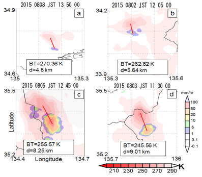 Fig. 1 The cloud height information retrieved from the distance between BT and cloud echo.
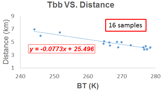 Fig. 2 Relationship between distance and brightness temperature (BT).
3. Result and Discussion
3.1 Parallax correction
The overlaying of BT data of Himawari-8 with radar echoes before and after Parallax corrections are shown in Fig. 3(a,b). The difference location of BT and radar echoes in Fig. 3a, where BT location is located in the northern part of radar echo is fixed by parallax equation as it is shown in Fig. 3b. Furthermore, by using the displacement vector of BT value, the albedo data also can be shifted to the original location. The overlaying of albedo and radar echoes before parallax correction is shown in Fig. 4a and after parallax correction in Fig. 4b. The surface and lower cloud albedo (0.1–0.4) which taking account in Fig. 4a is eliminated to see the pair of albedo and radar echoes clearly. Fig. 4b shows the overlaying of albedo (0.5–1) and radar echoes.
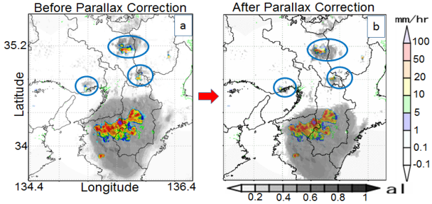 Fig. 3 Overlaying BT and radar echo on 8 August 2015 1440 JST, a) before parallax correction, b) after parallax correction.
 Fig. 4 Overlaying albedo and radar echo on 8 August 2015 1440 JST, a) before parallax correction, b) after parallax correction.
3.2 Case study of modified RDCA index
Fig. 5 shows the results of modified RDCA index, baby-rain-cell, and rainfall recorded on the ground at a different time. We discovered that the modified RDCA index first gives the value of 0.4 at 13:15, as shown in Figure 5a. Then, after five minutes, at 13:20, the baby-rain-cell was obtained from radar observation (Fig. 5b). Finally, the rainfall was detected on the ground at 13:30 (Fig. 5c), which is 15 minutes later than the prediction using the modified RDCA index.
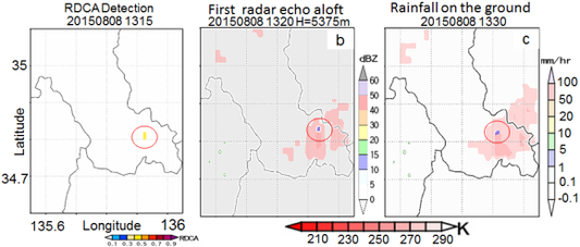 Fig. 5 Results of rain prediction using: a) modified RDCA index, b) baby-rain-cell, and c) rainfall detected on the ground.
4. Conclusions
In this study, we have investigated the capability of Himawari-8 observation data to detect the signal in the initial stage of cloud development earlier than the baby-rain-cell of GHR which can be detected weather radar. To fix parallax problem in Himawari-8 data we calibrated a parallax equation using the distance between cloud and radar echoes. The result of the case study of observation in Kinki region shows that utilizing the Himawari-8 data are capable to detect the important signal of a cloud in the initial stage before the occurrence of baby-rain-cell of GHR.
References
- Nakakita et al, “Short-term rainfall prediction method using a volume scanning radar and grid point value data from numerical weather prediction,” J. Geophys. Res., vol. 101, no. D21, p. 26181, 1996.
Go to Japanese page
PDF file(476 623 bytes) | Top
19 September, 2017